
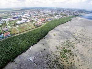
Guyana's coastal defences are getting a digital upgrade. On Wednesday, October 28, Agriculture Minister Zulfikar Mustapha announced that mangrove conservation data will be integrated into a new Situation Room at the Ministry of Agriculture, weeks ahead of the facility's launch.
The announcement came during the launch of the improved Guyana Mangrove Information System, known as GuyMIS, a platform developed with support from the Global Green Growth Institute that centralises satellite imagery, drone surveys, scientific monitoring and field observations into a single national resource, according to Kaieteur News.
A natural shield for a low-lying coast
Minister Mustapha did not mince words about what is at stake. Guyana's agricultural heartland sits on low-lying land along the Atlantic coast, and its protection rests in part on a belt of mangroves that absorbs wave energy and traps sediment.
“Mangroves are among the most remarkable natural assets our country possesses. They perform an extraordinary service to the nation. They help reduce wave energy, trap sediment, stabilise vulnerable sections of the coast, support biodiversity, and strengthen our resilience against the growing threats of climate change. They protect homes, livelihoods, drainage infrastructure, agricultural lands, and entire communities,” Mustapha said.
For a country where rice, sugar and vegetable production are concentrated on land barely above sea level, that protection is not an environmental luxury. It is an economic buffer. The Minister framed mangrove restoration as an investment in food security, in farmers who depend on protected land and in fisherfolk who rely on healthy ecosystems.
“For the Ministry of Agriculture, mangrove restoration is therefore not simply an environmental activity. It is an investment in food security and economic resilience,” Mustapha said.
That framing matters for taxpayers. Every dollar spent on mangrove belts is a dollar that does not go into concrete sea walls, which cost far more to build and maintain. Nature, in this case, is the cheaper engineer.
What GuyMIS 2.0 actually does
The improved platform, described by EIN Presswire as a centralised repository for mangrove distribution, restoration activities, coastal changes and erosion-prone areas, attempts to solve a problem that has less to do with science than with bureaucracy: data scattered across agencies that rarely speak to each other.
“The new Mangrove Information System platform brings together information from satellite imagery, drone surveys, scientific monitoring, and field observations into a single accessible system. It provides researchers, technical officers, policymakers, students, and community stakeholders with a powerful tool to understand changing coastal conditions, evaluate restoration efforts, and support evidence-based decision-making,” the Minister stated.
GGGI's Country Representative for the Eastern Caribbean and Guyana, Daniel Smith, was blunt about the challenge the platform addresses. Guyana has never lacked mangrove data; it has lacked coordination.
“Guyana has never been short of mangrove data. The challenge has been bringing that information together and making it easily accessible. GMIS 2.0 now provides a national home for mangrove change analysis, restoration and monitoring records, research, reports, photographs and videos,” Smith said.
Smith added that agencies handling forestry, sea defence, lands and surveys, hydrometeorology, local authorities and universities each hold part of the picture, and that each agency contributing data strengthens the analysis available to all others. He also noted that reliable information will help direct limited resources toward the coastal areas where restoration is most urgently required.
That point deserves emphasis. In a sector where public spending is often spread thin across too many projects, a system that tells decision-makers where money will do the most good is a welcome check on waste. Research published by Springer on national mangrove monitoring has found that many countries have advanced monitoring systems but struggle to connect them to climate policy; Guyana's move to link GuyMIS directly to a decision-support platform suggests it intends to avoid that trap.
The Situation Room: one platform to watch the sector
The larger story is the Situation Room itself. Mustapha confirmed the Ministry of Agriculture will launch the facility within weeks, describing it as a centralised decision-support platform that will integrate information from agricultural production, weather monitoring, drainage and irrigation systems, fisheries management and programme performance.
GuyMIS will feed directly into it, meaning coastal conditions and restoration records will sit alongside crop data and drainage figures in a single national monitoring framework. Decision-makers will be able to track restoration sites, identify vulnerable coastal areas, assess environmental risks and coordinate responses to threats facing farmland and coastal communities.
For a government that has pledged digital transformation across the public sector, the Situation Room is a test of whether data can actually change how decisions are made rather than simply decorate them. INews Guyana reported that the system was developed by the National Agricultural Research and Extension Institute, and the quality of its underlying data will determine whether the platform becomes a genuine management tool or an expensive display screen.
The early signs are encouraging. The platform draws on multiple independent sources, from satellites to field officers, which reduces the risk of any single agency shaping the picture to suit its own budget requests. Transparency of that kind is exactly what public spending in Guyana needs more of.
What happens next
The Ministry says the Situation Room will launch in the coming weeks. Its first real test will come with the next major coastal flood or drainage emergency, when the platform either shortens the response or exposes the gaps that remain between agencies still guarding their own files.
FAQ
When will the Agriculture Ministry's Situation Room launch?
Minister Zulfikar Mustapha said the Situation Room will launch in the coming weeks, as announced on Wednesday, October 28, 2026.
What is GuyMIS?
The Guyana Mangrove Information System is a centralised platform that combines satellite imagery, drone surveys, scientific monitoring and field observations on mangrove ecosystems, developed with support from the Global Green Growth Institute.
Who developed the upgraded mangrove information system?
INews Guyana and EIN Presswire report the system was developed by the National Agricultural Research and Extension Institute, with backing from GGGI.
Why are mangroves important to Guyana's coast?
Mangroves reduce wave energy, trap sediment and stabilise vulnerable sections of the coastline, protecting farmland, drainage infrastructure and communities from erosion and flooding.